Grosnez Castle stands on the headland at the extreme north-west of Jersey in Saint Ouen. Nobody really knows when it was built, but it was probably constructed in the 14th century, and was in ruins by 1540 and remains so today. The name is probably from the old Norse words for "grey headland" - grar nes - an accurate description of the site when seen from the sea - rather than from the French for big nose.
The castle may have been built on the orders of Warden of the Isles Sir John des Roches and was probably intended as a refuge for islanders if the French invaded, but they would never have withstood a siege because the nearest source of water was some 200 metres away.
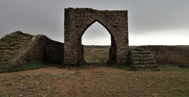
The walls were built from granite and are thickest on the landward side, because on the three other sides it is protected by steep cliffs some 60 metres high. The perimeter wall was about 250 metres long and enclosed an area roughly circular in shape. Archaeological excavations of the ditch which was spanned by a drawbridge revealed 12 carved corbels.
The gatehouse, which is substantially all that remains, was protected by the drawbridge and portcullis and would have been very difficult to capture.
The castle - really just a 'fort-of-refuge' due to lack of an internal water-supply - is said to have been twice captured by the French, in 1373 and 1381 - and it is surmised that it was perhaps demolished around the time of the French occupation of Jersey (1461–1468). Archaeologists who have studied the ruins suggest that the castle was deliberately destroyed, rather than left to crumble over time.
The following scenario has been put forward by one researcher:
"Some of its stone was used to enlarge St Ouen's Manor and perhaps build other properties in the area. The then Seigneur, Phillipe De Carteret, was already short of money, because his guardians had looted his estates while he was a minor, and when he came of age and got control of his own estates, it was recorded that 'alder trees grew in the roofless hall of his manor'.
"Rebuilding his manor house was a costly project, and he did not have any money after the theft of his inheritance by his guardians. Jersey was still being subjected to raids by Norman and Breton freebooters until the 1482 Papal 'Bull of Neutrality' put a stop to them. The raids affected the prosperity of the whole of Jersey, certainly including the Seigneur De Carteret, - who had begun petitioning Edward IV (by way of Governor Harliston) for a "License to Crenelate" [ie fortify] his manor against such raiders as early as 1478. The license was eventually granted in 1484, giving permission to demolish Grosnez Castle to obtain stone for the purpose. The fortified walls and the towers and gatehouse of St Ouen's Manor would have absorbed all the stone produced by dismantling the fort of refuge at Grosnez, and more."
In 1806, a naval signal station was established at Grosnez to send messages to Guernsey.
The name may, of course, simply mean "the Big Nose". But nes was Old Norse for "headland", and the Vikings gave this name to many of the promontories they passed. In England are Skegness, Sheerness, Shoeburyness, Dungeness, etc; in Northern France Gris Nez Blanc Nez, Nez de Jobourg, etc, as well as the Gros Nez near Flamanville. So Jersey's Rougenez, Nez du Guet, etc, probably have the same origin.
Grotness, in Shetland, is derived from Old Norse grjot, a rock, and this may have been the original name of our Grosnez, Grotnes, the Rocky Point, which Jersey later gallicised into its present spelling.
Grosnez forms the north-west corner of Jersey. From it can be seen on a clear day all the other Channel Islands, including Alderney. The most prominent thing on the point is a gaunt ruined castle. A space of almost an acre was once enclosed by a roughly circular wall. On three sides - west, north, and east - it was protected by precipitous cliffs; so there the wall was lower; but on the landward side it is even today 16 feet high, and once was higher. The gatehouse had a portcullis and battlemented roof, and on either side two projecting bastions with arrow-slits, through which archers could shoot down anyone who approached the gate. In front of this was a broad ditch cut through the solid rock, which was not easy to cross unless the drawbridge was down. Inside the walls can be traced the foundations of groups of small houses or shelters. A collection of carved corbels from the castle is preserved at the Museum.
This castle has little recorded history. In Leland's map of the Channel Islands, published about 1540, it is marked as Grosnes Castrum dirutum (Grosnez Castle, destroyed). In 1607 the Attorney-General challenged the right of the seigneur of St Ouen to hold his feudal court there, on the ground that all castles belong to the king; but the Commissioners ruled that, as it was "but a heap of rubbysh and stones", the seigneur might be left in possession.
In his The Bailiwick of Jersey, 20th century historian George Balleine suggests that 'four facts about the castle seem certain':
The ruins show that it was built in the bow-and-arrow age
Its corbels suggest that it must have had a machicoulis gallery with holes in the floor for dropping stones on the heads of enemies below; if so, it cannot be much earlier than the 14th century, when this form of defence first became common in northern Europe
It can never have been meant to stand a siege, for it had no well
The way its stones were thrown into the ditch shows that it was deliberately destroyed and did not crumble through age.
Balleine continued:
"The 14th century was the period of the Hundred Years War, when the French were making constant tip-and-run raids on the Island. The castle was probably a refuge to which St Ouen farmers hurried their wives and cattle whenever the church bells gave warning that the French had landed. Then they could man the walls and hold the enemy at bay, knowing that they would not settle down to a long, systematic siege. *But when we ask who destroyed the castle, we can only guess*. * Guess? Not any more, Philipe De carteret demolished Grosnez to fortify St Ouen's manor just as his descendent, the Lieut-Governor, demolished St. germanyne Castel to use the stone in the building of Elizabeth castle in the 17th century.]
"In the account of du Guesclin's raid in 1373 the Duke of Bourbon's standard-bearer reports: "We arrived in Jersey, where there are two castles. The Duke and his men set themselves in array against one and the Constable and his men against the other."
"We know that du Guesclin attacked Mont Orgueil. What can the other castle have been if it were not Grosnez? "Next morning they attacked, and the Duke captured his castle, the first to enter being Barberie, the Duke's carver. The Duke then joined the Constable, who had not yet taken the other castle." Placenames sometimes preserve facts that history has forgotten.
"A gully on the north-west of the castle is called Creux aux Francais. Does this imply that the Duke, instead of a frontal attack, led his men round to the back of the castle and stormed it at its weakest point? We cannot say. But its capture by the Duke of Bourbon is one possible date for its destruction. Before rejoining du Guesclin, he may have made certain that Grosnez could give no further trouble.
"Or was it destroyed in the French Occupation of 1461-68, during the Wars of the Roses? The de Carterets favoured the White Rose; so when the Red Rose won, their castle may have been dismantled. And this may explain why the Jersey chronicler never mentions Grosnez. Writing in the reign of Elizabeth, who was proud of her Lancastrian blood, he would not wish to call attention to the fact that his heroes, the de Carterets, had been on the other side. The flight of steps to the right of the arch was put there by the Societe Jersiaise to prevent visitors from damaging the moat by climbing over it.
"In recent years a lighthouse has been built half way down the cliff to guide ships coming from the Race of Alderney round the dangerous Paternoster Reef. It is worth descending to the platform of this lighthouse for the sake of the view along the coast."
This is the description of the castle in the 2020 Jersey Heritage Historic Environment Record:
"A 14th century fortification site of exceptional significance to the history of Jersey. The understanding of the site and its history is limited due to the lack of any recent documentary or archaeological research. Research into the castle's history was carried out as far back as 1897 (Le Cornu) and more recently in 1926 (Rybot). The archaeology, both structural and below ground, holds a great deal of evidence.
"Grosnez Castle is a fortified stronghold thought to have been built around 1330 on the orders of the Warden of the Isles, Sir John des Roches, to serve as a refuge from French attack for islanders in this part of Jersey. The 14th century was the period of the Hundred Years' War, when the French were making constant tip-and-run raids on the Island. The castle was twice captured by the French, in 1373 and 1381.
"The castle is said to have been captured by a French force led by the Duke of Bourbon in July 1373 in conjunction with an attack on Mont Orgueil by Bertrand du Guesclin. In the account of du Guesclin's raid in 1373 the Duke of Bourbon's standard-bearer reports: 'We arrived in Jersey, where there are two castles. The Duke and his men set themselves in array against one and the Constable and his men against the other.' It was captured again in 1381, and is thought to become a ruin around the time of the French occupation of Jersey (1461-1468).
"Local tradition has it that much of the stone was used to enlarge St Ouen's Manor around 1483, and that locals also took down the castle deliberately and used the stones on their own land. It is unlikely the seigneur of St Ouen would have been given such permission if the castle was still in use. On Leland's map of the Channel Islands, published about 1540, it is marked as Grosnes Castrum, dirutum (Grosnez Castle, destroyed). In 1607 the Attorney-General challenged the right of the seigneur of St Ouen to hold his feudal court there, on the grounds that all castles belong to the king; but the Commissioners ruled that, as it was 'but a heap of rubbysh and stones', the seigneur might be left in possession.
"A ruined fortified circular stone enclosure with a gatehouse, curtain walls and rock cut ditch, with traces of simple buildings to the interior. The granite curtain wall is about 250 metres long and encloses an area roughly circular in shape. The walls are thickest on the landward (south) side - the other sides (north, east and west) being protected by natural steep cliffs some 60 metres high. The most substantial standing structure is the gatehouse, which was protected by a drawbridge and portcullis. There is a portcullis groove descending to passage level, and below the groove is a pit for a counterpoise type drawbridge.
"Flanking the gatehouse are two D-shaped towers (now reduced to about 2m high). The west tower has remains of two arrow slits at ground level. Between the gatehouse and the east tower is a ramp up to the former wall-walk. There are two other towers further around on the east and west sides, but beyond them the natural defences presumably made flanking towers unnecessary. In front of the gatehouse is a broad ditch cut through the solid rock, originally crossed by the drawbridge. Archaeological excavations of the ditch revealed 12 carved corbels from the gatehouse (now on display at La Hougue Bie Museum). Inside the walls can be traced the foundations of groups of modest structures."
A detailed examination of the history and purpose of the castle was published in the 1926 Annual Bulletinof La Société Jersiaise
The ever recurring queries raised as to the origin and history of Grosnez Castle must be the excuse for returning to a discusssion of this subject, already dealt with by the late Colonel Le Cornu, in the Bulletin of this Society for 1897.
In attempting to arrive at some definite conclusions as to the origin of Grosnez Castle and the date of its construction, the subject should be examined from three points of view:
Architectural
Political and historical
Military.
In describing the architectural details of the fortified area known as Grosnez Castle, it is impossible to avoid a repetition of much that has already been touched upon by Colonel Le Cornu. It is now found necessary to issue an amended plan of the castle, so that no confusion may exist in the mind of the reader as to the relative positions of its various component, parts which are mentioned or described in this paper.
Referring to this plan it will be observed that the area enclosed by the defences was roughly circular in shape, measuring some 75 yards along the major or north-and-south diameter and about 60 yards along its minor or east-and-west diameter.
The total length of the enceinte or perimeter wall would have been about 250 yards. This wall was the sole line of defence, for no interior or second line appears to have existed. Once therefore this line were pierced, victory would have sided with the attackers; unless the defenders had taken the ordinary precaution of forming a strong reserve force or inlying picquet, which, by a vigourous counterstroke, would have hurled the invaders back over the battlements before they had had time to consolidate their positions or stampede the remaining defenders of tho walls.
The strongest parts of the fortification are naturally to be found fronting or commanding those landward approaches along which organised assaults might be expected.
Here then we have a ditch or fosse cut across the col connecting the promontory with the mainland. The western edge of the ditch was provided with a barrier wall. Towering above the ditch is the great gatehouse with its drawbridge, portcullis, massive doors, and machicolated and battlemented roof.
Flanking the ditch and gatehouse, at point blank range, are two strong two-story towers or bastions, comparable with, but somewhat lower than the towers along the outer walls of [[Mont Orgueil]]. Their walls, six feet thick, were pierced with arrow slits, their roofs were flat and battlemented.
From these works, archers and arbalisters could rain down arrows and quarrels with deadly effect on any intrepid attackers whose élan had carried them as far as the ditch. Their discomforture would be further increased by the missiles hurled over the crenellations or shot down through the machicoulis by the defenders of the gatehouse.
While such an attack was in progress, one must imagine that a heavy “covering fire” or “barrage” was sweeping through the crenellations and over the walls, driving the defenders to their covered positions. Even there, complete safety would not be found, for every exposed loop-hole would draw upon itself a concentrated and well directed rain of arrows. Meanwhile, the attack commander, appearing to expend all his efforts against the gatehouse line, might have launched a flank attack to the west.
Here, on the sloping rock-faces down by the sea, a force could move round towards the rear of the castle. Once out of dead ground, its success would depend on its energy as well as on the influence the false or holding attack might have had in drawing off towards the gatehouse the men detailed to hold the north-western walls.
In the attack and defence of medieval castles we see those principles applied which have existed from the earliest times and will persist until the corps à corps combat and the intaking of strong places cease to decide the fate of nations.
At a time when we imagine Grosnez Castle to have been an asylum for harried country folk, these principles were being applied in this very island at Mont Orgueil Castle by one of the greatest captains of the age and his determined and versatile opponent.
In the case of Grosnez Castle the rains before our eyes tell us that the attack finally beat the defence. Were onrushing men or the mere passage of years victors in this contest? History makes no reply.
As comparisons have often been made between the second gate at Mont Orgueil and the gate of Grosnez, plans, elevations and sections of the two buildings are herewith given. A general similarity between the two obviously exists and though in many details differences are apparent, it is reasonable to classify them both as works of one determinable date.
The gatehouses show remarkable similarities in plan, height, and interior construction. The working arrangements of the portcullises and drawbridges are almost identical. The masonry of walls and arches is of one type. The lateral doors leading out from the portcullis chambers on to the curtain battlements, show that the architects of both castles were influenced by similar military requirements.
As regards the differences, we find:
At Mont Orgueil the gatehouse was left open to the rear, so that should the enemy obtain possession of it he would have no cover to protect him from the storm of projectiles that would come hurtling in from the second line of defence. There being no second line of defence at Grosnez, the gatehouse was built up foursquare and formed, as it were, the vital point of the castle. It was the strongest element in the line and with its fall the defence would have collapsed.
No traces of a machicoulis gallery have been found over the Mont Orgueil gate and possibly none ever existed, for the approaches to the gate are directly commanded as well as flanked by the lofty curtain wall to the north.
The postern at Grosnez has no counterpart at Mont Orgueil.
So many good clues and clear indications still exist in the ruins at Grosnez, that it is possible to claim some justification for the outline and general detail of the reconstructions shown in the drawings. A note of warning, however, must be uttered in connection with the machicoulis gallery, as well as with the postern. When the castle ditch was cleared, a dozen large and roughly sculptured corbel stones were found lying in the débris. Four of these blocks had double skewbacks, showing that arches sprang from either side, and two of them had left skewbacks only. The remaining six all had level upper surfaces.
In the case of Grosnez Castle the rains before our eyes tell us that the attack finally beat the defence. Were onrushing men or the mere passage of years victors in this contest? History makes no reply.
Geographically the siting of castles was always arranged on a definite strategic plan, as for example the series of castles along the Welsh Marches and the Scottish border. Obviously while Normandy and England were united under the rule of the same sovereign, it was not of vital importance that powerful castles should be constructed in these islands. They were not likely to be attacked, except by pirates or marauders, and in the case of such raids we may presume that the type of fortification known as castles of refuge would have been deemed sufficient.
But after the separation of these islands from the Duchy of Normandy the position became very different and was one of considerable danger.
A new political issue had arisen. Hitherto the frontier of the English dominions on the Continent had been a varying line in France. Henceforward the frontier was shifted from the land to the sea, to the English Channel. With the loss of Normandy the English began to realise the full import of their insular position.
These islands were for many years to come the centre of the drama, and their retention by the Crown of England through the great struggle between the nations is a certain proof of the abiding sea-power of England.
The English were fully aware that the possession of the islands was of paramount importance for the protection of their commerce and the trade route from Gascony and Aquitaine. The French realised the value of the possession of the islands as a naval base. They knew that their failure to bring the islands under subjection, like the rest of Normandy, was due to lack of naval strength, and it is not surprising if they clung to the hope that some day they might be able to capture them.
History records their many efforts to attain this desire and how the islands were incessantly involved in the mighty struggle between the two great nations. The Assize Roll of 1309 relates how King John had had on two occasions to reconquer the islands from the French.
The strategic frontier of Jersey was its eastern coastline, lying closest to Normandy. Hence the ever increasing importance of Mont Orgueil Castle and the haste with which its fortifications were pushed forward in the early years of the 13th century.
Here it may be useful to take a cursory view of some of the more important attacks on Jersey during the period under review.
In 1295 a most determined attack was made on the islands. The destruction was great. The churches were sacked and the islanders, who had suffered greatly, received compensation out of the goods and chattels of the Normans in Jersey. Orders were given that monks and others residing in the island, who were connected with the Norman abbeys, should be kept at a distance from fortified places.
In 1389 came the invasion of Admiral Behuchet, followed closely by that of Robert Bertram, Marshall of France. Guernsey was captured and held by the French until 1345. Messengers from Jersey were hurriedly despatched to the King for aid. In their petition they said that the Island was so near their enemies that they might come from Normandy to the Castle “from the rising of the sun before one o’clock.” They pointed out the danger of the “passage towards Gascony”, if the islands were in the possession of the enemy. Ten years previously John de Roches, in a letter to the King, had emphasied the importance of the islands as posts of refuge for the mercantile marine.
In 1356 Castle Cornet in Guernsey was once more in the hands of the French.
In 1372 there is the important siege of Mont Orgueil Castle by the famous Constable of France, Bertrand du Guesclin, which can hardly be accounted more than a lucrative diversion. The islanders had to pay heavy ransom to obtain a cessation of hostilities.
In 1380 the French Admiral Jean de Vienne attacked the islands with the assistance of the garrison of St Malo.
In 1406 we have the attack of Pierre de Pontbriand and Pedro Nino; another filibustering expedition, accompanied by tho usual ransom.
Lastly we come to the most serious of all, the permanent occupation of Jersey for seven years (1461-68) by the French under Pierre de Brezé and his son, Comtes de Maulevrier.
Judging by the petitions sent to the English Government by the islanders in consequence of these attacks it would appear that in all cases, with the sole exception of the occupation of Jersey by Maulevrier, the island was overrun and its inhabitants despoiled. Apart from Mont Orgueil Castle no resistance appears to have been offered, except on the occasion of Pontbriand’s attack, when the island forces were assembled and fought two actions, and the reason would appear to be that unless ample warning were given it was impossible for the feudal levies to concentrate in time to oppose a landing.
Now let us inquire what is known of the history of Grosnez Castle. As a rule the word “Castle ” is a focus of history and sovereignty, yet Grosnez, though it bears the name of Castle, is almost as mysterious as Stonehenge.
The earliest references are to be found in old maps. In Leland s map of the Channel Islands (c 1540), preserved in his Collectanea in the Bodleian Library at Oxford, the site of Grosnez Castle is indicated, accompanied by a conventional sign and the following legend:
Castrum Grosnes dirutum (the ruined Castle of Grosnes), in Popinjay's Platte (1563) the site of the Castle is marked by a conventional sign and the word Grounyshe. In Norden’s map (1595) we find a conventional sign and Gronesse ca. In Mercator’s map (1606), a conventional sign and Gronese Castel. In Speed's map (1610) a conventional sign and Gronesse Castle. In Coronelli's map (1696) a conventional sign and Gronese Castel.
It is not until 1607 that we find a local documentary reference to the existence of the castle and then it is stated to be in ruins. Stranger still is the fact that the Castle is not mentioned in any of the Extentes of the Crown properties; and yet it is inconceivable that it should have been built or held by a private indivi-dual without the licence of the Crown.
In 1607 Royal Commissioners, sitting in Jersey, were called upon to decide a suit brought by the Attorney- General against Philippe de Carteret, Seigneur of St Ouen, “for keeping his Court upon the Castle of Grosnes”. The Attorney-General claimed that the Castle stood on His Majesty's Fief called l’Etacq (a doubtful statement); that, being a castle, the presumption was that it belonged to the Crown; and that, as it could not be proved that it belonged to the Seigneurie of St Ouen, “a nullitie might be made of the Seigneur’s last Court“ kept in the said Castle and of his possession thereby taken”.
The Seigneur of St Ouen pleaded that the Castle was “but a heape of rubbysh and stones”, that it was on his fief and belonged to the Seigneurie of St Ouen, and that he and his ancestors had always been in peaceable possession thereof. The Seigneur produced witnesses, some very old men, who deposed that during all their remembrance the Seigneurs of St Ouen had been in possession of the castle, and that they had seen many courts held there. They further declared that they had never heard of a fief called l’Etacq.
The Commissioners found on enquiry that the castle was, in fact, but a heap of stones, estimated to be worth only twenty sols or thereabouts. Upon which they decided to leave the Seigneur of St Ouen in possession “ until better proofe shall be made on his Majesty’s behalfe".
It is difficult to see daylight through these conflicting issues. Les Landes de St Ouen, upon which the castle is built, did form part in the 13th century of the ancient domain of the Crown; but there was certainly no such fief as “Fief de l’Etacq”.
We know also that it was not until 1483 that permission was granted to Philip de Carteret to crenelate St. Ouen’s Manor. A plausible suggestion may be therefore advanced that before the Manor was fortified Grosnez Castle was used as the place of retreat for the Seigneur and his tenants in times of danger.
Poingdestre in Cæsarea (1682) describes the Castle as “a slight thing like a gate without castle within; but famous for having been a retiring-place to Philip de Carteret, Seigneur of St Ouen, and his party against Peter de Brezé, pretending to be absolute lord of this island in the latter days of Henry VI”.
The historian Falle repeats Poingdestre’s statement, but adds the well-known story taken from Les Chroniques that Comte de Maulevrier never succeeded in subjugating the six western parishes of the island, which were held by Philippe de Carteret with Grosnez Castle as his headquarters. We know now that this statement will not bear inspection. The manuscript discovered in the Musée Condé at Chantilly and published in the Bulletin of 1924, establishes the fact beyond dispute that the whole island during Maulevrier’s occupation was under his rule.
So far as Grosnez Castle is concerned it is clear that Maulevrier could easily have made himself master of it, had he desired to do so. He would hardly have failed to recognize that an observation post at Grosnez was of vital importance to him, not only for the transmission of messages to Mont Orgueil Castle of the approach of hostile ships, but also for the purpose of maintaining his authority over the western parishes. The probability therefore is that he did capture Grosnez Castle in the early days of his occupation of the island.
Grosnez Castle was probably in the possession of the French when Sir Richard Harliston arrived in the island in 1468 and expelled them. It may possibly have been demolished by his orders when its raison d’être would have largely ceased. We have seen that according to Leland's map it was in ruins in 1540. Indeed the excavations made by this Society went to show that the destruction of the Castle had been carried out designedly. The manner in which the corbels, arch-stones, debris and masses of stone were found in the ditch, clearly proved that its destruction was not the result of decay through the ravages of time.
So much for the history or lack of history of the Castle. What can now be said as to its military importance and finally as to the date of its construction?
The approach of hostile expeditions issuing from the ports of the Cotentin in the daytime could always be observed from the heights of Mont Orgueil, but it was otherwise with the approaches from the English Channel. An observation post established at Grosnez would be a necessity. The position of this bold headland from a military point of view was not a bad one. It was open on the land side but with an approach both narrow and difficult, and it was protected by precipitous cliffs on the other sides. The dangers of surprise or of mining were small, such a post would need the minimum in the way of fortification and could be maintained by a small garrison.
Messages could be sent easily to Mont Orgueil Castle apprising the Governor of approaching vessels. If pirates or marauders landed in these parts of the island some refuge could be afforded within the enceinte to the fleeing inhabitants with their flocks and herds and the fortifications would be sufficient to hold out until the island and castle troops could advance to the relief. The countryside would be devastated but the looters would avoid strong places and be in a hurry to regain their ships while tides and fine weather served. But the castle could not have resisted a determined attack by superior forces.
We have seen that in Edward III ’s reign these islands suffered greatly from the continuous attacks of the French. In the second year of that King’s reign John de Roches was appointed Keeper with special instructions to repair the castles, much neglected during the governorship of Otho de Grandison. In that same year, 1328, the King issued an order to complete the fortification of Jerbourg Castle, near St Martin’s Point in Guernsey. This castle had been constructed by the inhabitants of the sister isle as a place of refuge, as they were unable to take refuge in Castle Cornet, which was surrounded by the sea. It had been built without the royal licence on the land of the Seigneur of Sausmarez, and a dispute arose as to its ownership. In 1330 Edward III granted it to Matthew de Sausmarez on condition “ that the men of the commonalty of the said island shall be received there with their goods and chattels in time of war”. Herein perhaps we may find an analogy which will help us to accept the suggestion already put forward that Grosnez Castle was used as a place of retreat in times of danger by the Seigneur of St Ouen and his vassals. Tradition connects the castle with the de Carteret family, who were certainly the predominant authority in the west of the Island, but who, on occasions of trouble were just as likely as not to find themselves cut off from the seat of government, Mont Orgueil Castle.
The evidence that the true role of Grosnez Castle was that of a place of refuge may be summarised as follows: —
Mont Orgueil Castle is in the extreme east of the island. Raiding parties operating in the middle of the island would cut off all refugees from the west, who would then be at their mercy. Grosnez Castle would alone have afforded them asylum.
Grosnez Castle dominates neither port, anchorage or village.
Having only one line of defence and no permanent water supply, the castle was clearly not intended for a lengthy occupation.
The Castle had no sally-ports to tho flanks, by which counter-attacks could issue. It was prepared for passive defence only.
Jerbourg was an observation post and a place of refuge, similar in type to Grosnez Castle. It played the same part as regards Castle Cornet as did Grosnez to Mont Orgueil. May it not then reasonably be concluded that it was during de Roche’s term of office (1328-30) that Grosnez Castle was built? This suggested date, as we have already seen, finds support in the architectural features of the remains.
The Castle of Grosnez is certainly primitive in structure, but in plan it skillfully embodies the most important military necessities of all time, which point to the Castle having been designed by a military engineer of full experience in the art of medieval warfare.
Though the research work carried out by this Society at the Castle in 1882-83 and in 1895-96 was extensive, there still remain some unexplored areas within the enceinte which might repay examination. The misleading heaps of stone in the centre of the enceinte and to the south of the ditch should certainly be removed and the ditch itself completely cleared, while some of the exposed masonry requires consolidation.