The Israeli West Bank barrier, comprising the West Bank Wall and the West Bank fence, is a separation barrier built by Israel along the Green Line and inside parts of the West Bank. Israel describes the wall as a necessary security barrier against Palestinian political violence; whereas Palestinians describe it as an element of racial segregation and a representation of Israeli apartheid, who often call it "Wall of Apartheid". At a total length of 708 kilometres (440 mi) upon completion, the route traced by the barrier is more than double the length of the Green Line, with 15% of its length running along the Green Line or inside Israel, and the remaining 85% running as much as 18 kilometres (11 mi) inside the West Bank, effectively isolating about 9% of the land and approximately 25,000 Palestinians from the rest of the Palestinian territory.
The barrier was built by Israel following a wave of Palestinian political violence and incidents of terrorism inside Israel during the Second Intifada, which began in September 2000 and ended in February 2005. The Israeli government cites a decreased number of suicide bombings carried out from the West Bank as evidence of its efficacy, after such attacks fell from 73 between 2000 and July 2003 (the completion of the first continuous segment) to 12 between August 2003 and the end of 2006. While the barrier was initially presented as a temporary security measure at a time of heightened tensions, it has since been associated with a future political border between Israel and the State of Palestine.
The barrier has drawn criticism from Palestinians, human rights groups, and members of the international community, who have all argued that it serves as evidence of Israel's intent to annex Palestinian land under the guise of security. It has also been alleged that the construction of the wall aims to undermine the Israeli–Palestinian peace process by unilaterally establishing new de facto borders. Key points of dispute are that it substantially deviates eastward from the Green Line, severely restricts the travel of many Palestinians, and impairs their ability to commute to work within the West Bank or to Israel. The International Court of Justice issued an advisory opinion finding that the barrier qualifies as a violation of international law. In 2003, the United Nations General Assembly adopted a resolution that charged Israel's building of the barrier to be a violation of international law and demanded its removal by a vote of 144–4 with 12 abstentions.
The walled sections of the barrier have become a canvas for graffiti art, with its Palestinian side illustrating opposition to the barrier, Palestinian resistance, their right to return, as well as human rights in general.
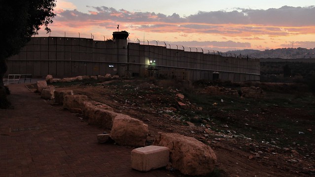
The barrier is described by the Israeli Defense Forces as a "multi-layered composite obstacle", with parts of it being consisting of a 9 metres (30 ft) high concrete wall, while others stretches consist of a multi-layered fence system, with three fences with pyramid-shaped stacks of barbed wire on the two outer fences and a lighter-weight fence with intrusion detection equipment in the middle; an anti-vehicle ditch; patrol roads on both sides; and a smooth strip of sand for "intrusion tracking".
Where the multi-layered fence system is employed, it contains an exclusion area of 60-metre (200 ft) in width on average,[33] with some sections having an exclusion area that reaches up to 100 metres (330 ft). The concrete wall has a width of 3 metres (9.8 ft), and the wall is 9 metres (30 ft) high.
The barrier runs partly along or near the 1949 Jordanian–Israeli armistice line ("Green Line") and partly through the Israeli-occupied West Bank diverging eastward from the armistice line by up to 20 km (12 mi) to include on the western side several of the areas with concentrations of highly populated Israeli settlements, such as East Jerusalem, the Ariel Bloc (Ariel, Karnei Shomron, Kedumim, Immanuel etc.), Gush Etzion, Givat Ze'ev, Oranit, and Maale Adumim.
The barrier nearly encircles some Palestinian towns, about 20% follows the armistice line, and a projected 77,000 ha (191,000 acres) or about 13.5% of the West Bank area is on the west side of the wall. According to a study of the April 2006 route by the Israeli human rights organization B'Tselem, 8.5% of the West Bank area will be on the Israeli side of the barrier after completion, and 3.4% partly or completely surrounded on the eastern side. Some 27,520 to 31,000 Palestinians will be captured on the Israeli side. Another 124,000, on the other hand, will effectively be controlled and isolated. Some 230,000 Palestinians in Jerusalem will be placed on the West Bank side. Most of the barrier[vague] was built at the northern and western edges of the West Bank, mostly beyond the Green Line and created 9 enclaves, which enclosed 15,783 ha (39,000 acres). An additional barrier, circa 10 km long, run south of Ramallah.
Israel states that the topography does not permit putting the barrier along the Green Line in some places because hills or tall buildings on the Palestinian side would make the barrier ineffective against terrorism. The International Court of Justice states that in such cases it is only legal to build the barrier inside Israel.
The barrier route has been challenged in court and changed several times. Argument presented to the court has reiterated that the cease-fire line of 1949 was negotiated "without prejudice to future territorial settlements or boundary lines" (Art. VI.9).
In 1992, the idea of creating a physical barrier between the Israeli and Palestinian populations was proposed by then-prime minister Yitzhak Rabin, following the murder of an Israeli teenage girl in Jerusalem. Rabin said that Israel must "take Gaza out of Tel Aviv" in order to minimize friction between the peoples.
Following an outbreak of violent incidents in Gaza in October 1994, Rabin said: "We have to decide on separation as a philosophy. There has to be a clear border. Without demarcating the lines, whoever wants to swallow 1.8 million Arabs will just bring greater support for Hamas." Following an attack on HaSharon Junction, near the city of Netanya, Rabin made his goals more specific: "This path must lead to a separation, though not according to the borders prior to 1967. We want to reach a separation between us and them. We do not want a majority of the Jewish residents of the state of Israel, 98% of whom live within the borders of sovereign Israel, including a united Jerusalem, to be subject to terrorism."
In 1994, the first section of a barrier (slabs of concrete contiguous for miles) was constructed. The section follows the border between Bat Hefer and Tulkarm communities.
In 1995, the Shahal commission was established by Yitzhak Rabin to discuss how to implement a barrier separating Israelis and Palestinians. Israeli Prime Minister Ehud Barak, prior to the Camp David 2000 Summit with Yasser Arafat, vowed to build a separation barrier, stating that it is "essential to the Palestinian nation in order to foster its national identity and independence without being dependent on the State of Israel".
In November 2000, during Israeli-Palestinian peace negotiations in Washington, Prime Minister Ehud Barak approved financing of a 74 km (46 mi) fence between the Wadi Ara region and Latrun. Not until 14 April 2002, the Cabinet of Prime Minister Ariel Sharon decided to implement the plan and establish a permanent barrier in the Seam Area. On 23 June 2002, the Ariel Sharon Government definitely approved the plan in principle and work at the barrier began.
At the end of 2002, due to government inaction, several localities who suffered the most from lack of a border barrier had already started to build the barrier using their own funds directly on the green-line.
By 2003, 180 km (112 mi) had been completed and in 2004, Israel started the southern part of the barrier.
The barrier and behind it Beit Surik. "The Beit Surik Case (HCJ 2056/04)" [HE] of the Supreme Court of Israel in 30 June 2004 set the standards of proportionality between Israeli security and the injury to the Palestinian residents and resulted in a change in the route of the barrier.
In February 2004, the Israeli government said it would review the route of the barrier in response to US and Palestinian concerns. In particular, Israeli cabinet members said modifications would be made to reduce the number of checkpoints Palestinians had to cross, and especially to reduce Palestinian hardship in areas such as the city of Qalqilyah which the barrier completely surrounds. On February 20, 2005, the Israeli cabinet approved the barrier's route on the same day it approved the execution of the Gaza disengagement plan. The length of the route was increased to 670 km (416 mi) (about twice the length of the Green Line) and would leave about 10% of the West Bank, including East Jerusalem and nearly 50,000 Palestinians on the Israeli side. It also put the large settlement Maale Adumim and the Gush Etzion bloc on the Israeli side of the barrier, effectively annexing them. The final route, when realized, closes the Wall separating East Jerusalem, including Maale Adumim, from the West Bank. Before, the exact route of the barrier had not been determined, and it had been alleged by opponents that the barrier route would encircle the Samarian highlands of the West Bank, separating them from the Jordan valley. In June 2004, in exchange for Finance Minister Benjamin Netanyahu's support Israel's planned withdrawal from Gaza, Prime Minister Sharon pledged to build an extension of the barrier to the east of the settlement Ariel to be completed before the finish of the withdrawal from the Gaza Strip. Despite the ICJ ruling that the wall beyond the Green Line is illegal, Ariel Sharon reiterated on September 8, 2004, that the large settlement blocs of Ariel, Ma'aleh Adumim and Gush Etzion will be on the Israeli side of the Barrier. He also decided that the Barrier would run east of Ariel, but its connection with the main fence be postponed. Israel appropriated Palestinian private land to build the fence upon and started preparations for constructing the wall to the farthest point ever inside the West Bank, 22 km (14 mi) beyond the Green Line, 3.5 km (2.2 mi) long, and 100 m (330 ft) wide.
In 2005, the Israeli Supreme Court made reference to the conditions and history that led to the building of the barrier. The Court described the history of violence against Israeli citizens since the breakout of the Second Intifada and the loss of life that ensued on the Israeli side. The court ruling also cited the attempts Israel had made to defend its citizens, including "military operations" carried out against "terrorist acts", and stated that these actions "did not provide a sufficient answer to the immediate need to stop the severe acts of terrorism. ... Despite all these measures, the terror did not come to an end. The attacks did not cease. Innocent people paid with both life and limb. This is the background behind the decision to construct the separation fence (Id., at p. 815)."
In 2006, 362 km (224.9 mi) of the barrier had been completed, 88 km (54.7 mi) was under construction and 253 km (157.2 mi) had not yet been started. On April 30, 2006, the route was revised by a cabinet decision, following a suicide bombing in Tel Aviv. In the Ariel area, the new route corrects an anomaly of the previous route that would have left thousands of Palestinians on the Israeli side. The Alfei Menashe settlement bloc was reduced in size, and the new plan leaves three groups of Palestinian houses on the Palestinian side of the fence. The barrier's route in the Jerusalem area will leave Beit Iksa on the Palestinian side; and Jaba on the Israeli side, but with a crossing to the Palestinian side at Tzurif. Further changes were made to the route around Eshkolot and Metzadot Yehuda, and the route from Metzadot to Har Choled was approved.
In 2012, 440 km (273.4 mi) (62%) of the barrier had been completed.
In September 2014, eight years after approving the 45 km stretch of barrier enclosing Gush Etzion, no progress had been made on it, and Israel reopened the debate. The fence is scheduled to go through the national park, the Nahal Rafaim valley, and the Palestinian village of Battir. The Israeli land appropriated in Gva'ot would be on the Palestinian side of the barrier. On 21 September 2014, the government voted to not reauthorize the barrier in the Gush Etzion area.
In 2022, 45 km (28.0 mi) of the barrier that had been built as a multi-layered fence were replaced by new sections of the 9-meter high concrete wall.
Bethlehem (/ˈbɛθlɪhɛm/; Arabic: بيت لحم, Bayt Laḥm, pronunciation; Hebrew: בֵּית לֶחֶם Bēṯ Leḥem) is a city in the Israeli-occupied West Bank of the State of Palestine, located about ten kilometres (six miles) south of Jerusalem. It is the capital of the Bethlehem Governorate, and has a population of approximately 25,000 people. The city's economy is largely tourist-driven; international tourism peaks around and during Christmas, when Christians embark on a pilgrimage to the Church of the Nativity, revered as the location of the Nativity of Jesus.
The earliest-known mention of Bethlehem is in the Amarna correspondence of ancient Egypt, dated to 1350–1330 BCE, when the town was inhabited by the Canaanites. In the Hebrew Bible, the period of the Israelites is described; it identifies Bethlehem as the birthplace of David. In the New Testament, the city is identified as the birthplace of Jesus of Nazareth. Under the Roman Empire, the city of Bethlehem was destroyed by Hadrian, but later rebuilt by Helena, and her son, Constantine the Great, who commissioned the Church of the Nativity in 327 CE. In 529, the Church of the Nativity was heavily damaged by Samaritans involved in the Samaritan revolts; following the victory of the Byzantine Empire, it was rebuilt by Justinian I.
Amidst the Muslim conquest of the Levant, Bethlehem became part of Jund Filastin in 637. Muslims continued to rule the city until 1099, when it was conquered by the Crusaders, who replaced the local Christian Greek Orthodox clergy with Catholic ones. In the mid-13th century, Bethlehem's walls were demolished by the Mamluk Sultanate. However, they were rebuilt by the Ottoman Empire in the 16th century, following the Ottoman–Mamluk War.[8] After the dissolution of the Ottoman Empire at the end of World War I, it became part of Mandatory Palestine until 1948, when it was annexed by Jordan during the 1948 Arab–Israeli War. During the 1967 Six Day War, Bethlehem was occupied by Israel along with the rest of the West Bank. Since the Oslo Accords between Israel and the Palestinian National Authority, Bethlehem has been designated as part of Area A of the West Bank, nominally rendering it as being under Palestinian control. Movement around the city is limited due to the Israeli West Bank barrier.
While it was historically a city of Arab Christians, Bethlehem now has a majority of Arab Muslims; it is still home to a significant community of Palestinian Christians, however it has dwindled significantly, mostly due to difficulties resulting from living under the Israeli occupation. Presently, Bethlehem has become encircled by dozens of Israeli settlements, which significantly hinder the ability of Palestinians in the city to openly access their land and livelihoods, which has contributed to the exodus of Palestinians.
The West Bank (Arabic: الضفة الغربية, romanized: aḍ-Ḍiffah al-Ġarbiyyah; Hebrew: הַגָּדָה הַמַּעֲרָבִית, romanized: HaGadáh HaMaʽarávit), so called due to its relation to the Jordan River, is the larger of the two Palestinian territories (the other being the Gaza Strip). A landlocked territory near the coast of the Mediterranean Sea in the Levant region of West Asia, it is bordered by Jordan and the Dead Sea to the east and by Israel (via the Green Line) to the south, west, and north. The territory has been under Israeli occupation since 1967.
The territory first emerged in the wake of the 1948 Arab–Israeli War as a region occupied and subsequently annexed by Jordan. Jordan ruled the territory until the 1967 Six-Day War, when it was occupied by Israel. Since then, Israel has administered the West Bank as the Judea and Samaria Area, expanding its claim into East Jerusalem in 1980. The mid-1990s Oslo Accords split the West Bank into three regional levels of Palestinian sovereignty, via the Palestinian National Authority (PNA): Area A (PNA), Area B (PNA and Israel), and Area C (Israel, comprising 60% of the West Bank). The PNA exercises total or partial civil administration over 165 Palestinian enclaves across the three areas.
The West Bank remains central to the Israeli–Palestinian conflict. The Palestinians consider it the heart of their envisioned state, along with the Gaza Strip. Right-wing and religious Israelis see it as their ancestral homeland, with numerous biblical sites. There is a push among some Israelis for partial or complete annexation of this land. Additionally, it is home to a rising number of Israeli settlers. Area C contains 230 Israeli settlements into which Israeli law is applied and under the Oslo Accords was supposed to be mostly transferred to the PNA by 1997, but this did not occur. The international community considers Israeli settlements in the West Bank to be illegal under international law. Citing the 1980 law in which Israel claimed Jerusalem as its capital, the 1994 Israel–Jordan peace treaty, and the Oslo Accords, a 2004 advisory ruling by the International Court of Justice concluded that the West Bank, including East Jerusalem, remain Israeli-occupied territory.
Palestine (Arabic: فلسطين, romanized: Filasṭīn), officially the State of Palestine (دولة فلسطين, Dawlat Filasṭīn), is a state in the Southern Levant region of West Asia. Founded on 15 November 1988 and officially governed by the Palestine Liberation Organization (PLO), it claims the West Bank (including East Jerusalem) and the Gaza Strip as its territory, all of which have been Israeli-occupied territories since the 1967 Six-Day War. The West Bank contains 165 Palestinian enclaves that are under partial Palestinian rule, but the remainder, including 200 Israeli settlements, is under full Israeli control. The Gaza Strip was governed by Egypt but conquered by Israel in 1967. Israel governed the region until it withdrew in 2005. The United Nations, the International Committee of the Red Cross, and various human-rights organizations still consider Gaza to be held under Israeli military occupation, due to what they regard as Israel's effective military control over the territory; Israel disputes this. Hamas seized power after winning the 2006 Palestinian legislative election. This has since been ensued by a blockade of the Gaza Strip by Israel and Egypt.
After World War II, in 1947, the United Nations (UN) adopted a Partition Plan for Mandatory Palestine, which recommended the creation of independent Arab and Jewish states and an internationalized Jerusalem. Immediately after the United Nations General Assembly adopted the plan as Resolution 181, a civil war broke out in Palestine, and the plan was not implemented. The day after the establishment of the State of Israel on 14 May 1948, neighboring Arab countries invaded the former British Mandate and engaged Israeli forces in the 1948 Arab–Israeli War. Later, the All-Palestine Government was established by the Arab League on 22 September 1948 to govern the All-Palestine Protectorate in the Egyptian-occupied Gaza Strip. It was soon recognized by all Arab League members except Transjordan, which had occupied and later annexed the West Bank, including East Jerusalem. Palestine is currently recognized by 138 of the 193 United Nations (UN) member states. Though jurisdiction of the All-Palestine Government was declared to cover the whole of the former Mandatory Palestine, its effective jurisdiction was limited to the Gaza Strip. During the Six-Day War in June 1967, Israel captured the Gaza Strip and the Sinai Peninsula from Egypt, the West Bank and East Jerusalem from Jordan, and the Golan Heights from Syria.
On 15 November 1988 in Algiers, Yasser Arafat, as Chairman of the PLO, issued the Palestinian Declaration of Independence, which established the State of Palestine. A year after the signing of the Oslo Accords in 1993, the Palestinian National Authority (PNA) was formed to govern (in varying degrees) areas A and B in the West Bank, comprising 165 enclaves, and the Gaza Strip. After Hamas became the PNA parliament's leading party in the most recent elections (2006), a conflict broke out between it and the Fatah party, leading to the Gaza Strip being taken over by Hamas in 2007 (two years after the Israeli disengagement).
The State of Palestine's mid-year population in 2021 was 5,227,193. Although Palestine claims Jerusalem as its capital, the city is under the control of Israel; both Palestinian and Israeli claims to the city are mostly unrecognized by the international community. Palestine is a member of the Arab League, the Organisation of Islamic Cooperation, the G77, the International Olympic Committee, as well as UNESCO, UNCTAD and the International Criminal Court. Following a failed attempt in 2011 to secure full United Nations member state status, the United Nations General Assembly voted in 2012 to recognize Palestine as a non-member observer state. On 26 February 2024, the Palestinian government collapsed, with the entire Palestinian government resigning, including the prime minister.