Likely due to this insufferable pandemic to date, I’ve gotten more inquiries than ever this year concerning the autumn conditions of the Blue Ridge Mountains… like I’m the trusted prognosticator. Ha! To be fair, have camera, will travel, and my friends know I keep my October calendar clear to make the most of what the highlands of North Carolina have to offer. So, I’m laying out my agenda this year, and the reasoning behind it… and, in terms of forecasting, I guarantee an accuracy of plus or minus 99%. Even a blind squirrel finds a nut now and then, so trust me! Or don’t.
Perhaps I should start with a short primer for those who are unaware why our mountains display such a wide spectrum of fall colors. All the Blue Ridge, save for a few balds and monadnocks (look that up in your Funk and Wagnall… then look up “Look that up in your Funk and Wagnall” … ha!) are covered in not just dense forests, but forests with such diversity as few other places in the world. Over 100 tree species endemic to both southern and northern forests are found there. The reason for that is the LGP, the Last Glacial Period. Glaciers picked up Alpine forests and moved them south as far as Virginia and dropped them among southern forests as they retreated. That was on a Tuesday at about teatime, 12,500 years ago, the end of the LGP. Since that time, trees found in forests far north of Virginia like balsam, hemlock, and mountain ash are thriving in the cooler climate of the high elevations of the Blue Ridge. Mountain ash, known as a sarvis tree in the UK, grows at sea level in Ireland. In these mountains, it’s a good indicator of the altitude you’re hiking. It’s found here only in elevations above 5,000 feet (1524 meters) … which begs a question. Not all the mountains of the Blue Ridge rise to 5,000 feet and higher. If the glaciers stopped at Virginia, why and how are the Alpine trees found here in North Carolina (with higher elevations), too? They didn’t just march across the lower mountains to the high regions.
A good bit of science involves observation. Here in Durham, a wooden fence separates our backyard from a surrounding bit of woods. I noticed a tree coming up on the backside of the fence last year, but I didn’t recognize what type of tree it was. A friend researched it and identified it as a mulberry. I only know of a couple of places around town where there are mulberry trees, yet I know of none near my house. A bird, that had apparently made a feast of mulberries, lit on my fence, took aim and squeezed off a shot of seeds. The same thing happened in these mountains, with twelve-millennia of forestation by wind, rain, and critter. In a roundabout way, I suppose they did march across.
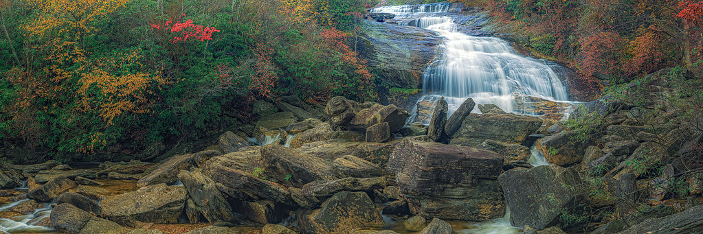
The picture I’m using to illustrate this post is of Second Falls. It is in the Shining Rock Wilderness off the Blue Ridge Parkway in a place known as Graveyard Fields at Milepost 418.8 (you can see Second Falls from the parkway at Milepost 418.5… here’s the view from there Autumn In the Clouds | There’s a lot to be said for autumn i… | Flickr). Sounds quite ominous, doesn’t it? Graveyard Fields got its name after a fire in 1925 razed 25,000 acres in the region. The blaze was so intense in this area that all that remained of the trees were ash heaps that reassembled a graveyard. The moniker stuck. No one, however, is quite sure how Second Falls got its name. One assumption is that Upper Falls, a little more than a mile upstream on the Yellow Prong, is the first. Since continuing upstream from Upper Falls is more than a bit hazardous, the assumption is exactly that.
While its name belies the beauty of Graveyard Fields, in autumn it’s sublime. This high mountain meadow is one of the first places along the Blue Ridge Parkway to hit peak autumn color. On good a good year, that usually occurs in October between the end of the first week and the beginning of the second… this image was taken on October 10, 2017, a very good year. That waterfall is surrounded by rhododendron, which are evergreens, though the cherries, maples, oaks, and blueberries leave no doubt as to the season. This year is shaping up to be a good year, too, if chaotic tropical storms stay out of the mountains for the foreseeable future.
So, what makes a good year for the brilliant hues of fall? A sufficient amount of water over the summer months is one thing. In dry years, the leaf color is muted, and they often dry out and turn brown while still on the tree. So far this year, rainfall has been quite sufficient, not just for leaves but also for waterfalls. Another consideration is temperature. Many autumns in the past have been more of the Indian summer variety with warm days extending well into October. The fall started off in the right direction with cooler weather. What triggers the change in leaf color isn’t cooler air temperatures, however; it starts once the ground cools to about 50°F (10°C). The Pisgah region of the Blue Ridge Parkway and south to Waterrock Knob has a lot of ground that pushes up beyond 6,000 ft. (1,828 meters). It is at those elevations where falls is first evident in this state. A rule of thumb concerning that is that the leaves change below those elevations at a rate of 100 ft. (30 meters) per day. My prediction is that, if high winds don’t enter too heavily in the mix, this should be a banner year for autumn in the Blue Ridge.
With that in mind, I’m leaving Sunday for a week’s stay in Pisgah Forest near Brevard just off Highway 276. That puts me well in range for DuPont State Park, the Blue Ridge Parkway, waterfalls off Highways 64 and 281, and perhaps even Cataloochee and Big Creek. When and where exactly has some to do with weather, especially if the entire area is overcast… those are good days for waterfalls, without contrastive light to obscure detail. My favorite sunset spot on the Blue Ridge Parkway is the Cowee Mountains Overlook at Milepost 430.7. I’ve told that to too many folks throughout the years already, so you might as well know, too. Many moons ago, I shared that spot with a few people and sometimes had it all to myself. Lately, I dubiously weigh up the crowd there with their tripods all lined up as I pull my own tripod from the back of the car. Just kidding. It’s feast of famine there for sunsets, but as Ansel Adams was prone to say, “f/8 and being there.” If you don’t know exactly what that means, you’re no photographer. My advice is that if there’s already a number a of photographers being there, just do what I do: throw out a few ‘scuse me, pardon mes and elbow your place amongst them. You’re welcome!
The next week, I’m moving out to a cabin between Linville and Newland near Linville Gorge, which should be in peak color then. Within range there is Linville Gorge, especially Wiseman’s View and Linville Falls, Grandfather Mountain, Rough Ridge (always a night hike there to catch sunrise), Beacon Heights, Boone Fork, Moses Cone House and Bass Lake, and Roan Highlands, especially Jane Bald (for sunset) and Round Bald. “Wait just a second… why would you go to a bald mountain for fall colors?” I’m glad you asked. Round Bald has great patches of blueberry bushes that turn brilliant red in the fall… with sunlight shining through them with a background of the colorful mountains surrounding the bald can be spectacular, particularly if sun and sky work together with some nice crepuscular rays. “What rays?” Funk and Wagnall. By the way, Price Lake is usually on that list. The dam there was damaged in the last tropical storm (remnant of Hurricane Fred) and drained the lake. The dam has since been repaired, but the lake level is still down, and it is closed to activities. I’m unsure how photo-worthy it is at this moment, though current rains should have made some difference.
A last thought, if you’re in this area and you haven’t had lunch at the Hampton Store in the community of Linville, shame on you. There are many bits and pieces I’ve not included here, though I realize that having used more than 10 words, I’ve likely overwhelmed many of you. If you made it this far, paste a gold star to your forehead. If you see me, drop by! Prognostication out.